What changed in McCracken
PVAToday: between two deliveries of the county’s record.
Every difference between two of the PVA’s exports, counted by kind, with the biggest of each.
- Before
- The PVA’s export of Feb 25, 20262026 roll · mccracken-2026-02-25
- After
- The PVA’s export of Sep 23, 2026, the latest2027 working roll · mccracken-2026-09-23
What a change is. A field-level difference between two exports of the PVA’s own record: the same parcel, the same field, a different value. It says what the office’s files say, not why, and it is not an appraisal. Counts and rows come from the what_changed tool on PVAToday’s MCP.
Changes by kind
6,914 changes in all, biggest kind first. The counts are exact; the kinds with a list below link to it.
- 1,665TransfersA new deed: the parcel changed hands.
- 1,554Value changesThis roll's assessed value differs from last roll's.
- 761Unassigned outlinesAn outline on the map with no parcel record behind it.counted only
- 718Account numbers reissuedSame deed, a new owner account number.counted only
- 588Exemptions on or offAn exemption, such as homestead, was added or removed.
- 554Owner name editsSame deed, the owner's name corrected or reworded.counted only
- 465Prior-year values restatedLast year's value changed after it was delivered.
- 229New constructionA building new to the record, dated in or after the earlier export's year.
- 190Site address editsThe parcel's street address reads differently.counted only
- 70Retired parcelsA parcel gone from both the property table and the map.
- 66New parcelsA parcel number that wasn't there before: splits, merges, new subdivisions.
- 54Class changesThe property class changed, such as residential to commercial.
Where
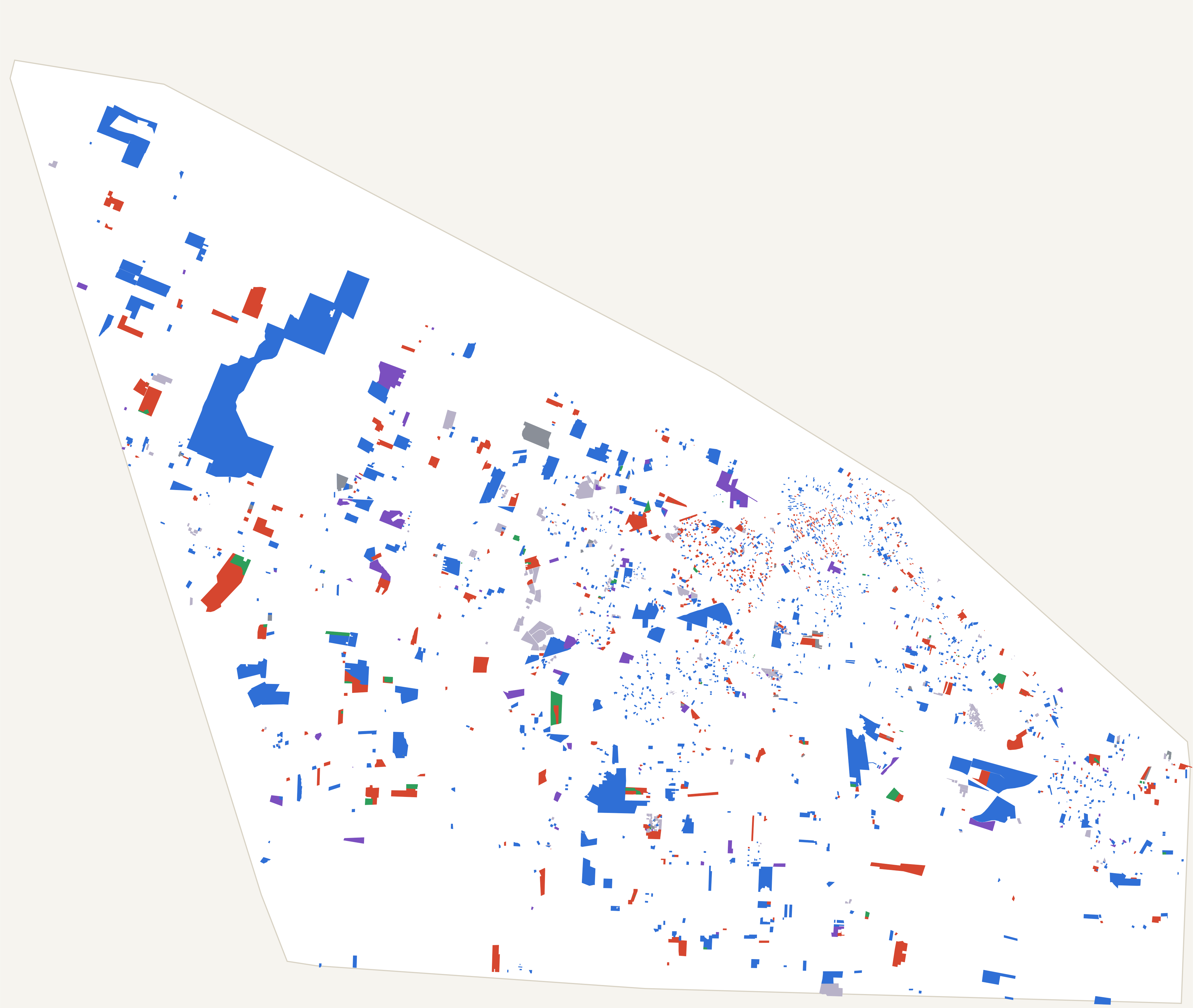
Transfers 1,665
A new deed: the parcel changed hands.
559 were arms-length sales with a price, at a median of $235,000. 130 carried no price. Buyers’ and sellers’ names are left out here.
The 10 highest-priced of 1,665, by the sale behind the new deed.
- Ask the chat about this change068-00-00-053100 MARSHALL COURTSold Jun 2, 2026, for $13,125,000arms-length
- Ask the chat about this change114-40-07-0122500 EICH ROADSold May 1, 2026, for $11,954,838not arms-length: out of state buyer
- Ask the chat about this change086-10-00-023.063925 COLEMAN CROSSING CIRCLESold Mar 3, 2026, for $11,200,000arms-length
- Ask the chat about this change086-10-00-023.073901 COLEMAN CROSSING CIRCLESold Mar 3, 2026, for $10,850,000arms-length
- Ask the chat about this change097-11-00-005.022831 LONE OAK ROADSold Aug 24, 2026, for $7,875,000arms-length
- Ask the chat about this change077-30-03-001110 QUAIL RUN DRIVESold Apr 7, 2026, for $7,100,000not arms-length: affiliated organizations
- Ask the chat about this change087-40-00-0271110 OLD NORTH FRIENDSHIP ROADSold Jul 9, 2026, for $5,100,000arms-length
- Ask the chat about this change054-00-00-023.017845 CARNEAL ROADSold Mar 27, 2026, for $4,300,000arms-length
- Ask the chat about this change075-00-00-147.025400 COMMERCE DRIVESold Aug 14, 2026, for $3,600,000not arms-length: affiliated organizations
- Ask the chat about this change088-34-08-0063001 LONE OAK ROADSold May 20, 2026, for $3,077,240not arms-length: out of state buyer
Full lists are for signed-in users and offices (coming).
Value changes 1,554
This roll's assessed value differs from last roll's.
967 went up and 587 went down, a net rise of $74,188,901; the median change was +11.1%. 5 went up from $0, which has no percentage; they are left out of the chart and the rankings.
Largest increases
The top 10 of 967, by percentage. Changes of 1,000% or more are left off this list.
- Ask the chat about this change089-00-00-030230 PEPPERS MILL DRIVE$55,000 → $590,000+973%
- Ask the chat about this change123-00-00-010LYDON ROAD$334 → $3,500+948%
- Ask the chat about this change104-14-01-0032516 HARRISON STREET$15,000 → $155,000+933%
- Ask the chat about this change105-00-00-024.58130 CLOVER CRESCENT$29,250 → $295,000+909%
- Ask the chat about this change077-30-05-0161850 NEW HOLT ROAD$13,000 → $130,000+900%
- Ask the chat about this change115-00-00-035SHADE TREE DRIVE$93,800 → $886,000+845%
- Ask the chat about this change097-40-00-015.10915 WAYSIDE DRIVE$30,000 → $269,600+799%
- Ask the chat about this change070-00-00-082.M6550 CLINTON ROAD$18,600 → $166,000+793%
- Ask the chat about this change112-13-22-001128 NORTH 3RD STREET$20,000 → $175,000+775%
- Ask the chat about this change105-00-00-024.73149 BLANTON COURT$35,000 → $295,400+744%
Largest decreases
The top 10 of 587, by percentage.
- Ask the chat about this change104-31-05-0171411 BURNETT STREET$2,500 → $0−100%
- Ask the chat about this change104-43-01-004407 SOUTH 17TH STREET$67,900 → $2,500−96.3%
- Ask the chat about this change120-22-07-012936 YARBRO LANE$115,400 → $5,000−95.7%
- Ask the chat about this change104-11-06-0101441 LANGSTAFF AVENUE$56,000 → $2,500−95.5%
- Ask the chat about this change075-00-00-1395536 CAIRO ROAD$3,219,885 → $174,990−94.6%
- Ask the chat about this change104-13-01-0191416 LANGSTAFF AVENUE$44,000 → $2,500−94.3%
- Ask the chat about this change112-44-00-0301616 BROAD STREET$26,480 → $1,530−94.2%
- Ask the chat about this change112-24-04-0041028 SOUTH 11TH STREET$40,900 → $2,500−93.9%
- Ask the chat about this change104-33-07-0021224 BERNHEIM AVENUE$36,700 → $2,500−93.2%
- Ask the chat about this change115-00-00-037SHADE TREE DRIVE$70,000 → $5,000−92.9%
Full lists are for signed-in users and offices (coming).
Exemptions on or off 588
An exemption, such as homestead, was added or removed.
258 added, 330 removed.
The 10 largest of 588, by the amount exempted.
- Ask the chat about this change105-00-00-0273047 JACKSON STREETExemption $0 → $753,635added
- Ask the chat about this change104-21-07-013308 JOE CLIFTON DRIVEExemption $0 → $234,000added
- Ask the chat about this change111-24-07-003400 NORTH LOOP ROADExemption $0 → $200,000added
- Ask the chat about this change104-22-10-0022936 CLARK STREETExemption $0 → $145,000added
- Ask the chat about this change104-31-04-0161311 BURNETT STREETExemption $0 → $131,989added
- Ask the chat about this change103-24-14-0061606 NORTH 12TH STREETExemption $0 → $84,160added
- Ask the chat about this change105-10-00-004450 BERGER ROADExemption $0 → $72,000added
- Ask the chat about this change112-21-06-0081202 TENNESSEE STREETExemption $0 → $64,200added
- Ask the chat about this change004-00-00-0028225 CONWAY ROADExemption $0 → $49,100added
- Ask the chat about this change007-00-00-010.016450 INGLESIDE ROADExemption $0 → $49,100added
Full lists are for signed-in users and offices (coming).
Prior-year values restated 465
Last year's value changed after it was delivered.
3 were restated from $0 and have no percentage; they aren’t ranked.
The 10 largest of 465, by percentage.
- Ask the chat about this change104-14-12-0122104 HARRISON STREET$2,500 → $172,900+6,816%
- Ask the chat about this change112-21-03-0041201 OSCAR CROSS AVENUE$1,500 → $83,575+5,472%
- Ask the chat about this change033-00-00-007.024225 KELLEY ROAD$3,000 → $143,900+4,697%
- Ask the chat about this change111-22-02-001921 NORTH 7TH STREET$6,900 → $137,700+1,896%
- Ask the chat about this change103-42-16-0031240 NORTH 12TH STREET$4,500 → $83,500+1,756%
- Ask the chat about this change115-00-00-089.022390 CLARKLINE ROAD$20,000 → $361,700+1,709%
- Ask the chat about this change087-44-00-028700 OLD NORTH FRIENDSHIP ROAD$90,000 → $1,438,400+1,498%
- Ask the chat about this change121-20-01-0031820 DEBBY DRIVE$12,500 → $188,500+1,408%
- Ask the chat about this change077-30-02-016.42140 SHADOWOOD COURT$35,000 → $399,300+1,041%
- Ask the chat about this change105-00-00-0174031 SCHNEIDMAN ROAD$14,300 → $157,335+1,000%
Full lists are for signed-in users and offices (coming).
New construction 229
A building new to the record, dated in or after the earlier export's year.
229 buildings on 190 parcels.
The 10 most valuable of 229, by the building’s value.
- Ask the chat about this change076-00-00-007.025925 OLD HIGHWAY 60Elite pain and spine, built 2026, 20,398 sq ft, valued $3,218,800
- Ask the chat about this change075-00-00-147.065657 COMMERCE DRIVECrypto mining building, built 2026, 14,000 sq ft, valued $2,627,500
- Ask the chat about this change104-22-05-009368 SOUTH 31ST STREETOffice, built 2026, 7,092 sq ft, valued $2,061,000
- Ask the chat about this change085-20-00-033.125116 CAIRO ROADGas station, built 2026, 8,298 sq ft, valued $1,417,500
- Ask the chat about this change086-10-00-027.02435 JORDAN DRIVEStore, built 2026, 5,058 sq ft, valued $1,290,600
- Ask the chat about this change076-40-00-100.032536 NEW HOLT ROADApartments 1 bldg 2601 (8 units), built 2026, 6,410 sq ft, valued $1,060,100
- Ask the chat about this change087-44-00-028700 OLD NORTH FRIENDSHIP ROADApartment Building Bldg #2 (2100-2105), built 2026, 8,832 sq ft, valued $902,600
- Ask the chat about this change087-44-00-028700 OLD NORTH FRIENDSHIP ROADApartment Building Bldg #3 (3100-3105), built 2026, 8,832 sq ft, valued $902,600
- Ask the chat about this change068-00-00-018.012710 MAYFIELD METROPOLIS ROADHouse, built 2026, 9,443 sq ft, valued $900,000
- Ask the chat about this change077-30-02-016.512181 NEW HOLT ROADCPA BLDG A, built 2026, 10,985 sq ft, valued $885,600
Full lists are for signed-in users and offices (coming).
Retired parcels 70
A parcel gone from both the property table and the map.
10 of 70, in parcel-number order.
- Ask the chat about this change014-00-00-0284545 MAGRUDER VILLAGEGone from the property table and the map
- Ask the chat about this change014-00-00-028.074535 BETHEL CHURCH ROADGone from the property table and the map
- Ask the chat about this change023-20-00-025.0111250 MANN STREETGone from the property table and the map
- Ask the chat about this change033-00-00-0044215 HOBBS ROADGone from the property table and the map
- Ask the chat about this change034-00-00-0192810 BIGGS ROADGone from the property table and the map
- Ask the chat about this change034-00-00-050.019455 OLD HINKLEVILLE ROADGone from the property table and the map
- Ask the chat about this change044-20-00-031.019819 WOODVILLE ROADGone from the property table and the map
- Ask the chat about this change044-20-00-032.019975 WOODVILLE ROADGone from the property table and the map
- Ask the chat about this change048-00-00-054.ML018140 LOIS LANEGone from the property table and the map
- Ask the chat about this change048-00-00-054.ML33100 KRIS LANEGone from the property table and the map
Full lists are for signed-in users and offices (coming).
New parcels 66
A parcel number that wasn't there before: splits, merges, new subdivisions.
10 of 66, in parcel-number order.
- Ask the chat about this change013-00-00-017T12816 HELM ROADNew parcel, COMMERCIAL (40)
- Ask the chat about this change013-00-00-032.024900 NEW LIBERTY CHURCH ROADNew parcel, COMMERCIAL (40)
- Ask the chat about this change023-00-00-009M3955 RICE SPRINGS ROADNew parcel, RESIDENTIAL (10)
- Ask the chat about this change023-00-00-041.03OLD HIGHWAY 60New parcel, FARM (20)
- Ask the chat about this change023-20-00-025M11250 MANN STREETNew parcel, MOBILE/MANUFAC HOME (70)
- Ask the chat about this change034-00-00-047.01METROPOLIS LAKE ROADNew parcel, RESIDENTIAL (10)
- Ask the chat about this change034-00-00-108.012685 BIGGS ROADNew parcel, RESIDENTIAL (10)
- Ask the chat about this change046-00-00-039.042585 GHOLSON ROADNew parcel, FARM (20)
- Ask the chat about this change047-00-00-006.101940 GHOLSON ROADNew parcel, RESIDENTIAL (10)
- Ask the chat about this change047-00-00-033.04OFF WILSON ROADNew parcel, FARM (20)
Full lists are for signed-in users and offices (coming).
Class changes 54
The property class changed, such as residential to commercial.
10 of 54, in parcel-number order.
- Ask the chat about this change005-00-00-014.0214165 OGDEN LANDING ROADMOBILE/MANUFAC HOME (70) → RESIDENTIAL (10)
- Ask the chat about this change022-00-00-0284310 RICE SPRINGS ROADRESIDENTIAL (10) → COMMERCIAL (40)
- Ask the chat about this change023-20-00-06011510 HIGHWAY 60 WESTRESIDENTIAL (10) → COMMERCIAL (40)
- Ask the chat about this change023-40-00-07210375 OLD HIGHWAY 60RESIDENTIAL (10) → COMMERCIAL (40)
- Ask the chat about this change033-00-00-0134205 MAGRUDER ROADRESIDENTIAL (10) → FARM (20)
- Ask the chat about this change034-00-00-0459420 HIGHWAY 60 WESTRESIDENTIAL (10) → COMMERCIAL (40)
- Ask the chat about this change036-00-00-017.0210875 HIGHWAY 286MOBILE/MANUFAC HOME (70) → RESIDENTIAL (10)
- Ask the chat about this change036-00-00-030.028850 HARRIS ROADRESIDENTIAL (10) → FARM (20)
- Ask the chat about this change044-20-00-0319889 WOODVILLE ROADCOMMERCIAL (40) → FARM (20)
- Ask the chat about this change044-20-00-050.019840 WOODVILLE ROADRESIDENTIAL (10) → COMMERCIAL (40)
Full lists are for signed-in users and offices (coming).
Counted, not listed
Owner name edits and reissued account numbers are rows of owners’ names and the office’s account numbers; the others have nothing to rank. They are counted above; full lists are for signed-in users and offices (coming).
- Unassigned outlines 761
- Account numbers reissued 718
- Owner name edits 554
- Site address edits 190
About this page
- The counts are exact, from
what_changed. Each list shows the top 10 of its kind; full lists are for signed-in users and offices (coming). - No owner, buyer or seller names are shown here.
- A published delivery never changes, so each pair is worked out once and kept; only which delivery is the latest moves.
- “Ask the chat” opens chat.pva.today with a question ready to send.
- PVAToday holds 2 published McCracken deliveries so far, so this is the only pair; each new delivery adds one.
- Every delivery, with when it arrived and what it carried, is on the McCracken page.